WristRoute is a standalone Apple Watch GPS app for hiking, biking, and other outdoor activities. Neither the iPhone nor internet is needed for field operation.
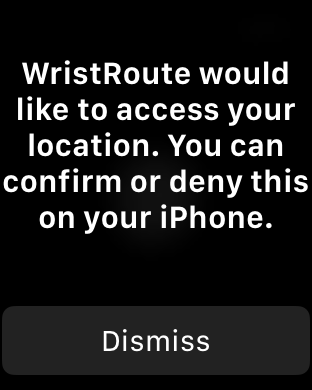
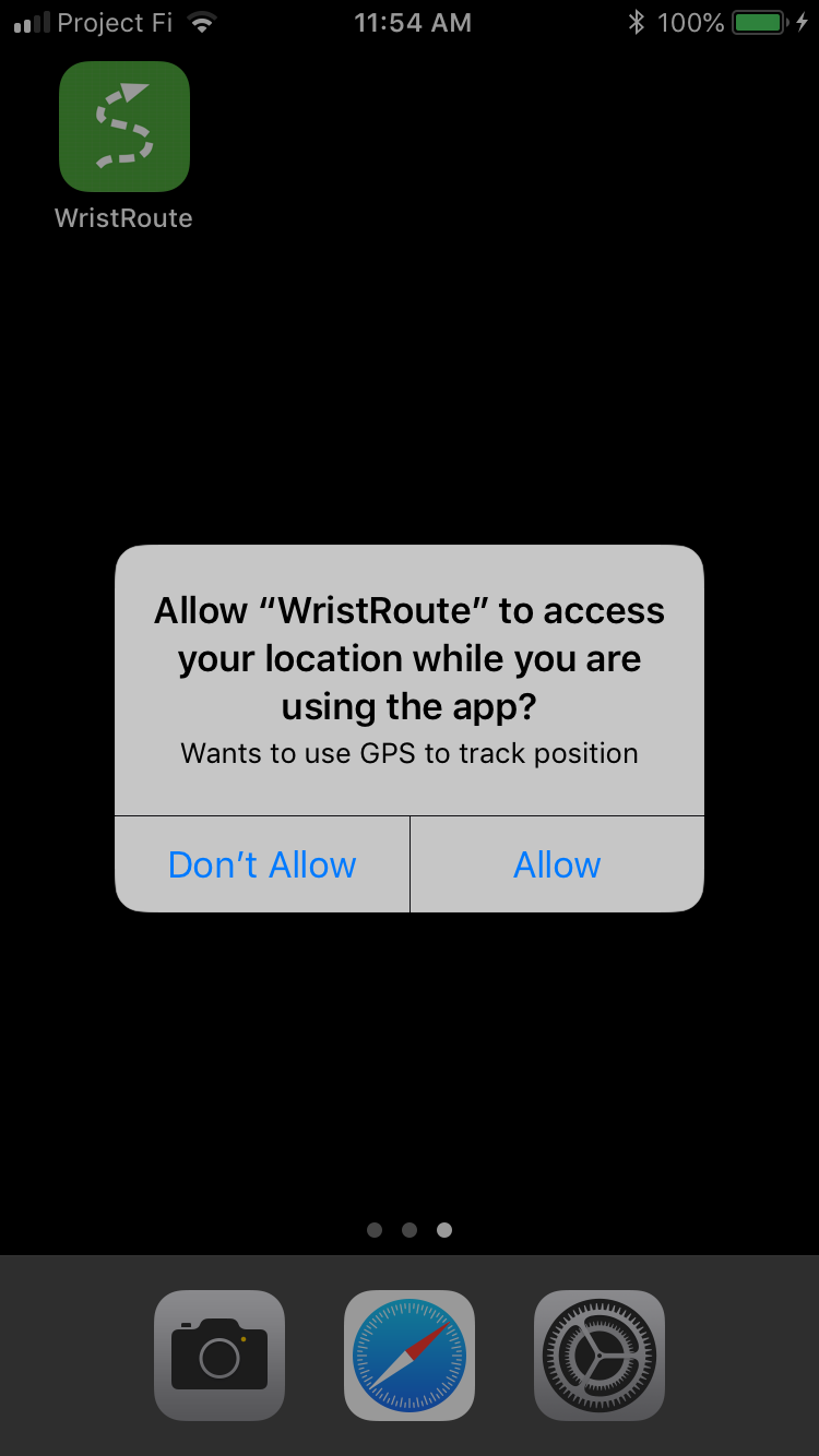
When first run, WristRoute prompts to enable access to your location (i.e. use the GPS). Prompts appear on both the Apple Watch and the iPhone. The permission must be granted on the iPhone.
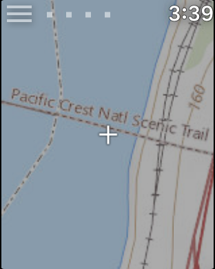
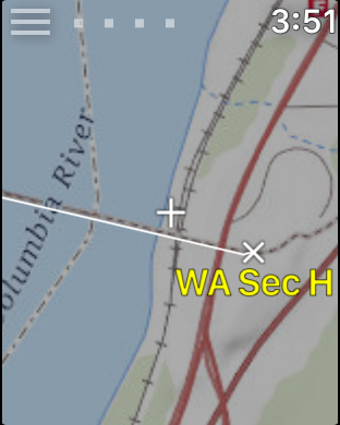
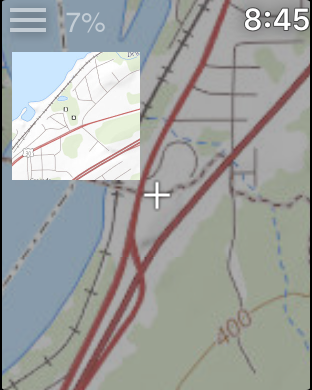
WristRoute displays your GPS position as a crosshair cursor in
the center of a topographic map.
Scroll the map by dragging the screen with your finger. The scrolled
map will return to the GPS position the next time the screen turns
off for over one second and then turns back on, such as when you
lower and then raise your wrist ("wrist up"), or when the screen
blanks to save power.
GPS reception quality is displayed by up to four small squares at
the upper left of the screen. If GPS reception is good (3 dots or
more, horizontal accuracy 32 meters or better), WristRoute adds a
yellow dot to the map at your position. A new dot is added every 100
feet of motion.
If you scroll the map the GPS reception quality dots are replaced
with N^, reminding you that North is up on the map (even if Settings... North up is off)
and letting you know that the current GPS position is not being
displayed. If you
press N^ then the current GPS position will be redisplayed, as if
you had lowered and raised your wrist.
Map images are downloaded from the internet as they are needed. Maps
are stored in a persistent cache for later offline use.
The map displayed is US Topo, the latest topographic map from USGS.
Outside of the continental United States a map based on
OpenStreetMap is used instead. See Settings for more map options.
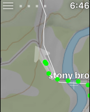
If GPS is active an arrow is displayed in the center of the screen underlaying the crosshair cursor showing the compass direction the watch is facing.
(Note that prior to Apple Watch Series 5 the hardware does not have a compass, so the software uses successive GPS positions to determine this heading. Consequently, the arrow is most accurate when your recent motion is steady.)
Turn off Settings... North up to rotate the map in
the direction of motion, in which case the arrow will always point
straight up while the map itself rotates.
The iPhone side of WristRoute is used to transfer GPX (Global Positioning eXchange) files between iPhone storage and the watch. Note: start WristRoute on the watch before copying a GPX file.
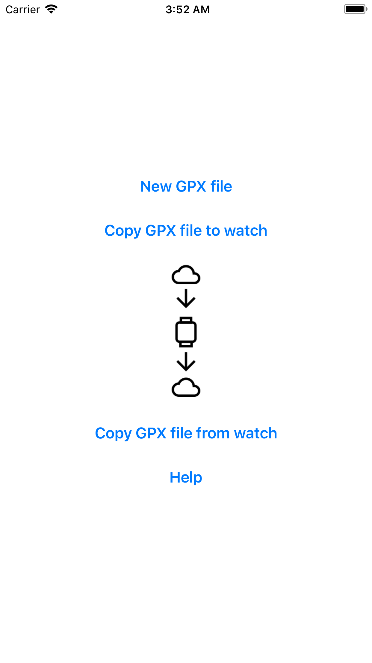
GPX files contain waypoints, routes, and tracks. You can find GPX files for many popular routes on the internet. Download the GPX file to your iCloud drive or other iPhone storage, then transfer it to the watch. You can also create GPX files with programs such as Eastridge Technology's Route3D.
GPX files copied from the watch include all new tracks and waypoints that were created on the watch since the last GPX file was loaded.
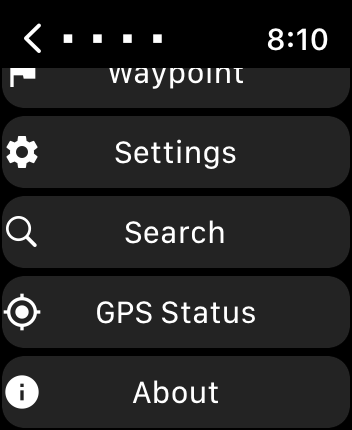
Pressing the menu symbol at the upper left of the watch screen displays the main menu.
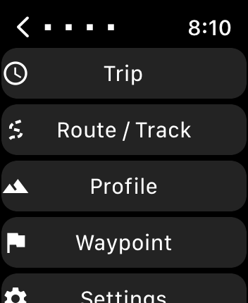
Scroll down with the Apple Watch digital crown to see all of the
menu.
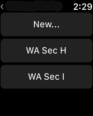
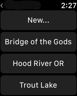
The Route/Track menu is used to load a route or track from the GPX file. Routes and tracks are treated the same, and both are referred to as track below.
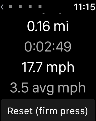
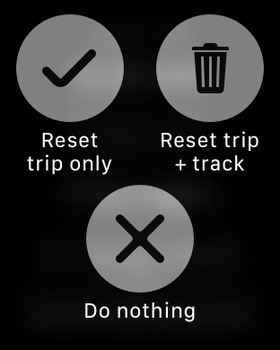
New... With trip data saves track history in a new track. Track history is accumulated in permanent storage until it is cleared with the Trip... Reset trip+track menu. To track continuously in the background use Settings... GPS On rather than GPS Battery Saver.
New... None resets the current track to none. All tracks in the GPX file resume displaying as yellow lines.
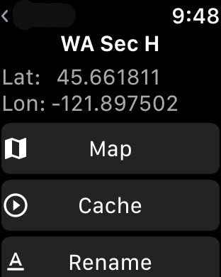
Selecting a track from the scrolling list (or on the map) brings up a track title page. If the track has a description it appears below the track name.
Map draws the track as a white line on the map, with the
name of the track in yellow marking the start.
Cache returns to the map screen and animates the route, which
caches all the map images at the current zoom level for later
offline use. The display may pause as images are downloaded.
Rename brings up a screen which allows the track to be
renamed. Note that microphone dictation only works if the iPhone is
in communication with the watch.
Delete deletes the track.
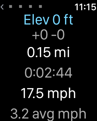
Profile displays an elevation profile of the current track. The
white line cursor shows your position along the track
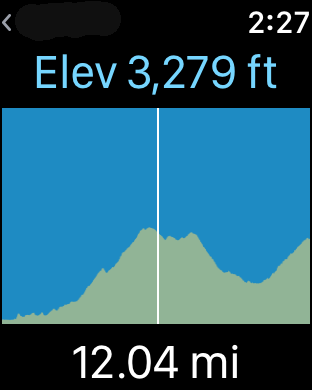
The profile can be expanded and contracted by turning the digital
crown. You can drag the cursor to check elevations and to scroll the
screen. Relative distances from the starting position are displayed in yellow when dragging the cursor.
If the profile is flat then the track may not contain elevation
data. Route3D can add elevation to a track if needed.
New... saves the current map cursor position as a new
waypoint.
Selecting a waypoint from the scrolling list (or on the map) brings up a waypoint title page. If the waypoint has a description it appears below the button area, along with latitude, longitude, and, if recorded, elevation.
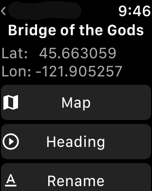
Map shows the waypoint on the map screen.
Rename renames the waypoint.
Delete deletes the waypoint.
Heading shows a screen with heading and distance to the
waypoint from the current GPS position, as well as the current
elevation.
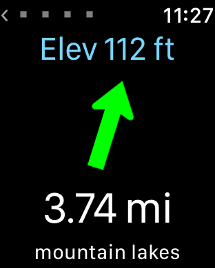
Starting with Apple Watch Series 5 the watch has a hardware compass. The heading arrow is the compass direction.
Prior to Apple Watch Series 5 there is no hardware compass and
the heading arrow is relative to the direction of motion. Heading is determined by
successive GPS locations. This works best when recent motion has
been in a straight line. If heading cannot be determined then the
heading arrow is dimmed.
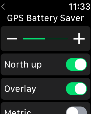
North up if on, map is always displayed with North up. If off, the map rotates to the current compass heading (Apple Watch Series 5 or later) or GPS course direction of motion (Apple Watch Series 4 or earlier. Be aware that unlike a compass, the direction of motion does not update if you stand still and spin about).
Overlay enables display of waypoints and tracks on the map.
Metric displays metric units (m, km) instead of English units (ft, mi).
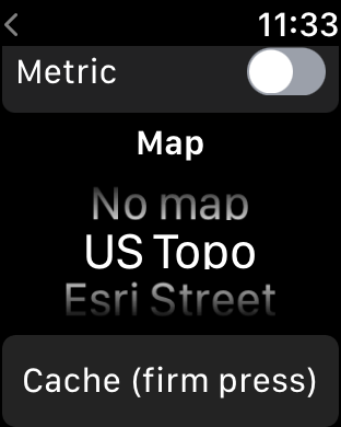
Map selects the current map display.
No map turns off the map, which saves battery and makes the
display more readable in bright sunlight.
US Topo is the default map for the Continental USA.
Esri Street is a world street map used outside of the
Continental USA.
USGS 24K displays USGS Historical Topographic 1:24,000
scale maps. Although older, these hand drawn maps are often more
readable when contours become complex. The first time these maps
are accessed there may be a longer delay than with the other maps.
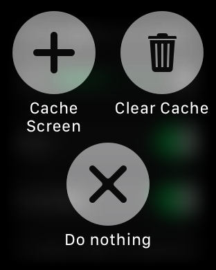
Percent loaded is displayed at upper left, above a thumbnail of
the map image being loaded.
The cache operation can be canceled by pressing the menu button.
Searches for place names such as "Princeton,NJ". Select one of the results and the map will recenter on that location.
If the search fails try adding a '?' on the end, e.g. "Prince?" matches any name beginning with "Prince".
You may also enter a decimal WGS84 latitude longitude coordinate such as "37.3290 -122.00198", which will recenter the map on that location.
Search requires an internet connection.
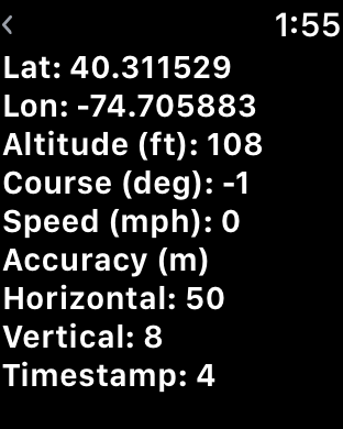
The GPS Status screen lists the raw status of the GPS. A course
of -1 indicates an unknown heading, otherwise it is degrees from
North. Timestamp is seconds since starting the GPS Status screen;
a negative value indicates loss of GPS signal.
To save a continuous track do the following:
- Settings... GPS... On
- Trip... Reset trip+track at start of track.
- Route/Track... New... With trip data when done recording the track.
- Settings.. GPS... Off or Battery Saver when done.
Before a trip it is useful to develop a GPX route or to find a GPX track that you will be following. Add significant waypoints. Load the GPX file to your iCloud Drive, then use the WristRoute iPhone app to transfer the file to the WristRoute Apple Watch app. Use Route/Track... Cache to cache maps for the route at the detail levels you need. Use Settings... Cache... Cache screen to cache larger areas where you might need maps.
For overnight hiking trips bring a battery pack to recharge watch. Turn off Settings... GPS when not tracking. Set both watch and iPhone to airplane mode (or turn off iPhone) except when doing iPhone file transfers.